Karstic Topography-a Crucial Role in Modeling Karstic Hydrological Process
Karst environments are unique ecohydrological features compared with other landscape environments. The world's karst regions cover ~20% (or 2.22 × 10⁷ km2) of the ice‐free continental area on Earth and supply food and water to ~25% of the world's population. However, water shortages in karst regions have become a common problem.
The complex karstic topography, discontinuous soil distribution, and interlaced matrices (micropores, small fissures, and fractures) and conduits (large fractures from the karstification), result in rapid loss of surface water derived from precipitation to the underground systems in karst regions.
Based on a semi-distributed hydrological model (named VarKarst), a team of researchers from the Institute of Subtropical Agriculture, Chinese Academy of Sciences (ISA) built an improved optimization scheme for representing karstic hydrological processes in hillslopes and depressions.
The researchers found that the separation of hillslopes and depressions is a necessary operation in representing karstic hydrology.
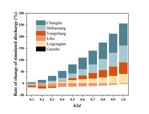
"Model parameter (h2d), which determined the fraction of flow from hillslopes to depressions, is the highest sensitivity in our improved VarKarst model",said XU Chaohao, the first author on the paper.
In addition, the distribution of soil depth and epikarst depth, and fast and slow flow in undersurface are the additional factors that affecting the karstic hydrological processes. The improved VarKarst model considered the combination of randomly distributed soil and epikarst depths (RSE), fast‐slow flow (FS), and hillslopes and depressions (HD), and improved model performance compared with original VarKarst model, especially when reproducing discharge of peaks and recessions. The calibrated and validated KGE (a model performance indicator) ranged from 0.54 to 0.89 in seven selected karstic catchments.
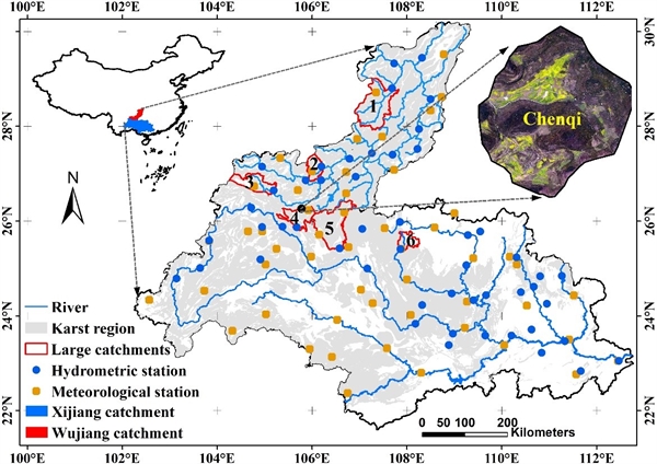
"Our improved VarKarst model also can support a reference of average of soil and epikarst depth at catchment scale",said Chaohao Xu. Simulated average soil depth on hillslopes was 426.5 mm in Chenqi catchment, a small catchment located in Puding, Anshun city, Guangxi province, while the measured average soil depth of seven line transects on hillslope was 415.2 mm.
The study entitled "An Improved Optimization Scheme for Representing Hillslopes and Depressions in Karst Hydrology" was published in the Water Resources Research, supported by the National Natural Science Foundation of China (41571130073), the Youth Innovation Team Project of ISA, CAS (2017QNCXTD_XXL), the Open Fund of Key Laboratory of Agro‐ecological Processes in Subtropical Region, CAS (ISA2018302), and CAS Interdisciplinary Innovation Team.

Figure 1: The six large catchments (1. Changba; 2. Shibantang; 3. Yangchang; 4. Gaoche; 5. Leigongtan; 6. Libo) and one small catchment (Chenqi) that constituted the study area are in the Xijiang and Wujiang catchments, Southwest China

Figure 2: Importance of parameter h2d, which represent the flow from hillslope to depression, in separating hillslopes and depressions when simulating karstic discharge
Contact: Xu Xianli
E-mail: xianlixu@isa.ac.cn
Institute of Subtropical Agriculture, Chinese Academy of Sciences
Download attachments: